A map layer package has been set up to ensure that the key data held in the carriageway table (basis of the network) is exported without requiring you to modify the layers to do so. The map layer package is [carrway] Network Export to file.
This has two separate layers:
- [cway] Network Export – Existing: the current network including any provincial or district roads loaded into the database (these can be filtered out in the external system by using asset_owner).
- [cway] Network Export – Proposed: only those unconstructed sections of the missing links (those sections which are currently provincial roads will be included in the Existing layer) and proposed roads.
If the export only needs the existing network or the missing links, you can export from that layer alone to complete the task, however if the export needs both the existing network and the missing links, then the export must be done on each layer separately (this will create two separate export files).
To do so, select the layer you want to use and make sure that it’s active: Left-click on the layer bar on the map (making sure to not click on the tick box or filter button), this brings up the layer menu, from which you want to select the option to Export:
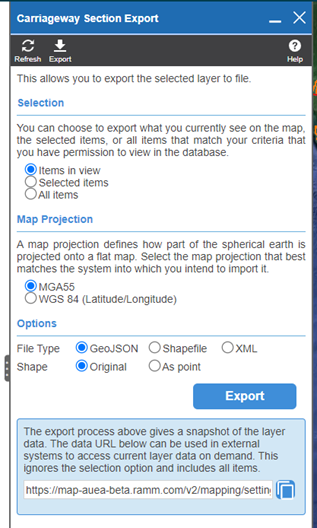
As we’re exporting the full network, the selection should be set to All Items:
The other two options can be used when only a particular section of the network is needed to be exported:
- Items in View exports only those items you can see on screen, so if you zoom into the Milne Bay Province, for example, you will only export those roads which are visible on the screen based on what you can see.
- Selected items uses the Select by Rectangle or Select by Lasso options to allow you to draw a shape on the map which in this case will select all the carriageway sections which are at least partially within the shape you draw (note that it selects the individual carriageway sections, not the full road – if you draw a shape that includes all of Morobe province, you will only get the carriageway sections on the Highlands Highway, as an example, where the carriageway sections are at least partially within the Morobe province).
The next set of options determines if the exported file is exported in northing/easting co-ordinates (MGA55) or latitude/longitude (WGS84) – unless the person you’re providing the exported data to specifically requests latitude/longitude, leave the selection at the default MGA55.
The final set of options determines the file type that is exported and whether the network is exported as lines (Original) or points (this option defaults to Original – make sure that As Point is not selected, otherwise you’ll end up exporting a bunch of random dots around the map rather than a network!).
Unless the person you’re exporting the file for requests otherwise, select the Shapefile option:
Clicking the Export button will then download the file into the default download directory for the browser you are using.
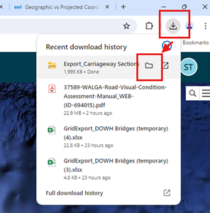
The file will be named something like “Export_Carriageway_Sections” and may have a number (5) (example) behind it depending on how many times this has been exported previously (it adds the number behind the file to make the file name unique).
This can be accessed using the downloads button in the browser as follows (note that clicking on the folder beside the filename opens the folder with that specific file highlighted).
- Chrome – once the download starts the download icon will appear in the top right of the browser – once the download is completed, click on this, and then click on the folder icon that appears when you mouse over the file in the list.
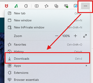
- Edge – once the download is complete the download window will pop up and then disappear. To access the file after the download window disappears, click on the three dots icon in the top left and select downloads from the menu:
 Then when the download window opens, click on the folder that appears as you mouse over the file you want:
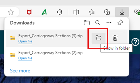

 Then when the download window opens, click on the folder that appears as you mouse over the file you want:
