| Article Purpose | To provide the technical requirements and specifications to undertake a survey for the collection of road roughness data using the TotalPave App. |
| Intended Users | Anyone who is responsible for collecting roughness data whether it be provincial staff, AMB staff or contracted suppliers. |
| Last Reviewed | 1 October 2024 |
Background
Information related to the PNG National Road Network is recorded in the AWM (ThinkProject ASSET & WORK MANAGEMENT - AWM formerly RAMM) road management system.
The AWM database system contains the master versions of the road network and all managed assets.
DoWH intends to maintain up to date knowledge of its pavement assets. To support this it undertakes road roughness surveys on an annual or bi-annual basis (depending on road hierarchy).
DoWH undertakes road condition surveys in order to have current and appropriate information to inform its road management plans and support its network planning and maintenance programming.
In general the Survey setup and delivery process is as follows:

Scope of Work
Introduction
This road survey is to collect comprehensive and fit for purpose road roughness data (measured in IRI) for the nominated roads or road sections.
The following high level process provides broader context of the activities involved either side of the data collection work.

Requirements & Methodology
Step 1: Survey Preparation
To be Provided by DoWH Asset Management Branch (AMB)
- The DoWH TotalPave Administrator will assign and provide a login to TotalPave.
- TotalPave Portal Access - https://portal.totalpave.com
- Training on:
- DoWH Site Safety procedures and protocols.
- Safe Traffic Control at Road Works DoWH Guide - PNG DoWH - Field Guide for Safe Traffic Control at Works.pdf
- TotalPave Portal features and survey verification methodology.
- TotalPave Survey app features, survey methodology and data upload.
- Road sections to be surveyed (if not already provide in a contract or agreement)
- A list of the road names, including start and end chainages and lengths, from the AWM database system to be surveyed.
Vehicle & Equipment
The Consultant is to provide all equipment and undertake the survey in accordance with the following requirements:
- Advise the AMB of which vehicle(s) and smartphone model(s) will be used during the road survey and receive confirmation from AMB that these are acceptable. The following provides some guidance on what will be acceptable.
- Survey vehicle – Toyota Land Cruiser, 5 door, diesel, 2014 model year or later or approved equivalent. The surveyor may use more than one vehicle simultaneously to survey different roads provided the survey data from each vehicle meet all the requirements of this specification.
- Mobile Phone –Samsung Galaxy A71 or approved higher model, Android smartphone, with registered SIM Card and minimum 32 GB Micro SD Flash Storage.
- Download the TotalPave IRI App from the Google Play Store or Apple App Store and install it on to the mobile phone that will be used during the survey.
- Login to TotalPave IRI app and the TotalPave Portal with the login details provided by the AMB.
- Setup the Phone mount inside the vehicle, using the following instructions.
Approved Car Phone Holder, compatible with the smartphone(s) being used. A model similar to the one in the image is acceptable. It must be mounted to the windscreen with suction caps and be as rigid as possible.
 Typical Carphone Holder
 Phone-holder Mounting Method
 In Vehicle Placement and Setup
 Test Runs
- Conduct a road survey practice run, under DoWH supervision, on not more than 10km in length along a target road, easily accessible by road from the training location. Practice survey data upload to the TotalPave Portal and verify uploaded data on Portal, as basis of payment.
- Conduct “Extended Trial Run”, under DoWH observation, approximately 100km in length (outbound and inbound) along a target road, easily accessible by road from the training location. The objective of this trial run is to demonstrate proficiency in data collection, data upload, using the TotalPave IRI app and verification using the TotalPave Portal.
Step 2: Record Road Roughness using TotalPave
Following the instructions provided by TotalPave, start the survey in the TotalPave IRI app and drive the nominated road sections.
The surveyor must:
- Communicate and coordinate with the DoWH Provincial Works Manager(s) before commencement of surveys in each province.
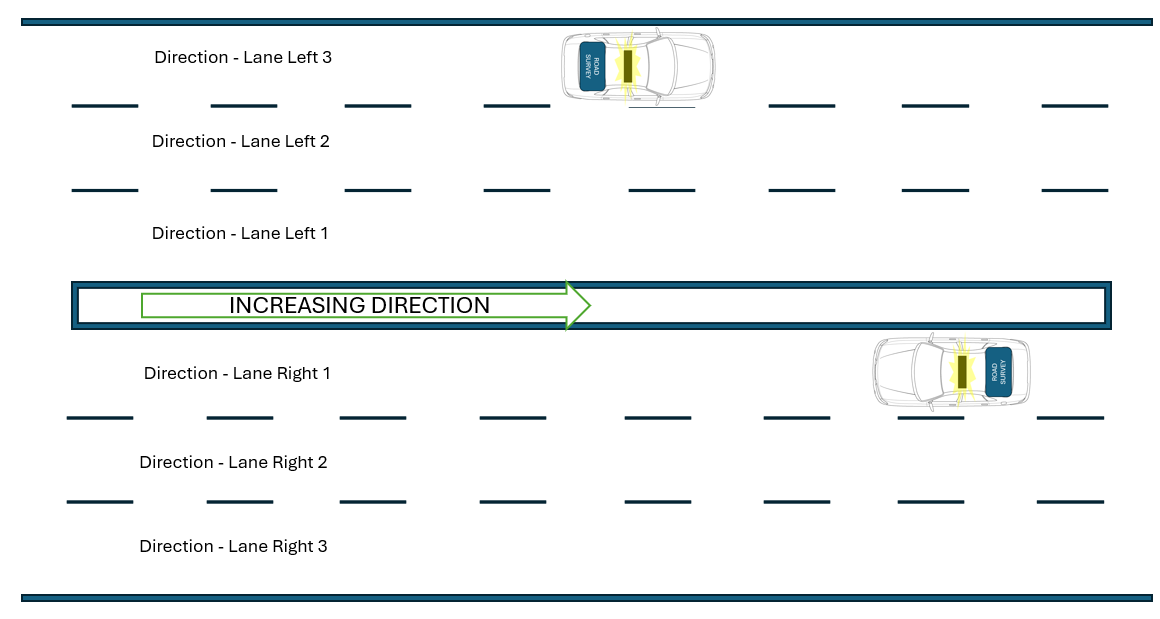
- Survey each road section in both travel directions to capture the roughness of the lanes in both directions.
- For dual carriageway/divided road sections, undertake additional surveys to measure each additional lane in both travel directions. Lane numbering convention is from Centreline e.g. If multi lane carriageway Left Lane 1 is the lane closest to the Centreline on the true left side, Left Lane 2 is the next lane and so on.

- Maintain a steady course and constant speed which does not exceed the legal speed limit nor any lower speed, above which, it would be unsafe to travel. Where safe to do so, the survey travel speed shall be 45 km/hr.
- Not survey at a speed less than 20 km/hr - where the TotalPave IRI App will enter “Slow Mode” and cease to take measurements.
- As far as it is practicable and safe to do so, the survey vehicle should follow the wheel paths expected for normal traffic without deviating around potholes, damaged pavement or other minor obstructions.
- Maintain a survey log, noting each road section completed and include notes on any issues encountered and in particular the reason any road sections couldn't be surveyed.
Step 3: Upload Data to TotalPave Online Portal
Once the survey has been completed, the surveyor shall:
- Upload the data to the TotalPave Portal using the upload function on the TotalPave IRI App.
- Undertake quality assurance of the collected data in the TotalPave Portal
- Once the surveyor is satisfied of the quality and completeness of the data collected, advise the AMB of the survey completion and submit their survey log to AMB via email.
If the survey takes longer than a week, then it is good practice to upload the data to the TotalPave Portal and complete quality assurance on a weekly basis.
Quality Assurance
The surveyor is responsible for undertaking the survey in a manner which ensures that all data submitted are of high quality, accurate, complete and fit for the purpose required.
During the survey:
- Ensure adequate road survey safety equipment and practices are implemented during the data collection.
As a minimum, the information is to be collected, analysed and uploaded to the TotalPave Portal in a manner that:
- Is consistent, accurate, error-free, high-quality raw data
- Is verifiable on the TotalPave Portal map
- Is complete with no data gaps (all 100 m sections must have an IRI reading for the date of the survey run) showing on the TotalPave Portal map for each road section surveyed, in both directions.
If the survey is being undertaken by a consultant, DoWH reserves the right for one AMB staff member to join the Consultant’s on-site survey team(s) for quality review purposes. The Consultant is to allow for one (only) seating place in its primary survey vehicle to accommodate an AMB staff member and shall provide a minimum of five business days notice of any change of travel dates that have been previously agreed with DoWH (eg. through approval of the Consultant’s Workplan). All direct costs (eg. travel airfares, accommodation, per diems etc) incurred by a DoWH staff member accompanying the Consultant’s survey team are the responsibility of the client.
Stakeholders
| Stakeholder | Role |
|---|---|
| DoWH AMB | The Asset Management Branch is responsible for this specification, uploading roughness data to the AWM database system and utilising the data for the support of programme development and further analysis. |
| Provincial Works Manager (PWM) | The PWM is the most senior DoWH role based in each province and should be advised of any surveying to be done on national roads in their province. |
Support
Issues Data Collection (if required)
Data to be Collected
For the nominated roads or road sections collect the following data:
- 'Issues' data, including photographic imagery and text description of notable issues for:
- pavements
- slope stability
- drainage structure
- road furniture
Use the TotalPave Tracker application installed on approved Android or iOS mobile smartphones to collect the 'issues' data.TotalPave Tracker and uploaded to the TotalPave Portal by the Consultant with accompanying notes to articulate the issue being tagged.
• TotalPave Tracker Android App, downloadable from Play Store and installed on both smartphones, shall be used to collect details of significant pavement, drainage structure, roadside and safety issues encountered during the survey run. Photographic data and relevant notes shall be submitted to the TotalPave Portal, using the second smartphone.
• TotalPave Tracker Android App for tracking and reporting issues on the road pavement, drainage structures, etc, downloadable from Play Store and installed on smartphones.
• Other Survey Data – The Consultant is to maintain and submit a running log of all field surveys undertaken. At a minimum the log is to record the date, time start and end, start, turn-around and end locations (if the return-leg of the survey is conducted during the same session as the outward leg, then the start and end location should be the same), names of significant bridges/junctions/LRPs passed and changes of pavement type (Sealed/unsealed/earth) along each surveyed road. Logged locations are to be referenced by both time (hh:mm) and vehicle odometer (trip meter) reading indicating the distance from a known Location Reference start point. The AWM chainage and GPS coordinates of each pavement surface change point (end of seal, start of seal etc) are to be taken from the georeferenced survey imagery and a list of the point coordinates (tagged by chainage, time and point type) submitted electronically.
