Task
As part of the roll-out of the AWM system, the network within the system must be reviewed and validated to ensure that:
- It provides an accurate spatial representation of the national road network.
- The details of the network such as road hierarchy are accurate.
Provincial staff will review the roads within their province to confirm their accuracy.
The task has three separate parts, and in general should be undertaken in the order listed:
- Roads missing, incorrectly included, or incorrectly named
- Road alignment
- Carriageway details
Any issues identified in the process of working through this task should be logged in AWM using the “Data Fix Request” table - see the How To guide “Working with Data Fixes” the specifics of adding and working with these records.
As part of the task, each staff member will update the table “Network Validation Tracker” with their progress (see Tracking the Task below for the process).
To assist in the task, a map layer package “Network Review” has been created.
Roads missing/incorrectly included/naming
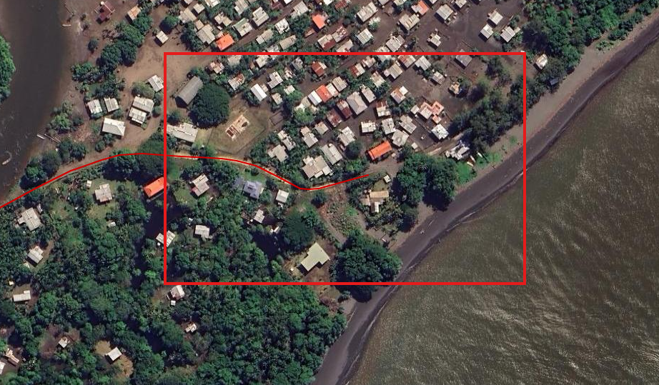
The first step is to review the road network in the province and confirm that all the national roads in the province are represented on the map – for any roads that are missing, a data fix should be raised using a rough line to trace the extents of the missing road:
The second step is to make sure that there are no roads included in the system which should not be in the system – at this stage only National Route, National Main and National District roads should be in AWM, with National Institute and Provincial roads excluded (with a rare exception for Provincial roads that form part of the missing link projects where they will be taken over as national roads at the end of the project).
For roads that shouldn’t be in the system, raise a data fix (point) on the road that should be removed with the brief description outlining why the road should be removed (e.g. “Provincial Road”, “National Institute”).
Finally, the road names themselves should be reviewed to make sure that there are no misspelt or incorrect names in the database.
In this case, raise a data fix (point) on the road and include the corrected name of the road in the data fix request.
Road alignment
After checking for missing or incorrect roads, the next step is to look at each road and confirm the following:
- The road start/end locations are correct – for most this should be obvious, but some roads end in locations such as small villages where it can be uncertain as to the exact location the road should terminate.
 Where the start or end is incorrect, raise a data fix to identify the issue:
- If it is a shortening of the existing centreline, use a point data fix at the location the centreline should be trimmed to.
- If it requires the extension of the centreline, use a rough line data fix (as shown for adding a new road above) to indicate where the additional centreline should go.
- The road centreline alignment is correct – either confirming against the aerial imagery, or where you are aware of project changes to the alignment that the aerials are too old to show.
 In both cases, a data fix (line) should be raised. If the aerial is clear (as in the image above), a rough line can be used just to indicate the fix required – if the change is based on local knowledge of a project that is not shown in the aerial, the line must be much more detailed and accurate as it will be the only guide available to make the change.
 Where the start or end is incorrect, raise a data fix to identify the issue:
 In both cases, a data fix (line) should be raised. If the aerial is clear (as in the image above), a rough line can be used just to indicate the fix required – if the change is based on local knowledge of a project that is not shown in the aerial, the line must be much more detailed and accurate as it will be the only guide available to make the change.
Carriageway details
Once the overall road alignment has been checked and any fixes required logged, the final stage is to check the details of the individual carriageway sections, focusing on the following fields:
- Network Type - is this section of road sealed, unsealed, or a 4-wheel drive track?
The quickest way to work through this information is to set up thematic layers on the map to display the data values.
The carriageway splits can be made easier by turning on the “Show Line Direction” in the configuration menu as this will cause a little arrow to display at the end of each carriageway section, making it easier to identify where each section starts and ends:
If the data is incorrect, a data fix should be raised at the location, either a line or point as follows:
- If the issue applies to the entire carriageway section (wrong hierarchy for example), a point data fix within the start/end location of the carriageway section is sufficient.
- If the issue applies to only part of the carriageway section, either:
- A line (start and end points need to be accurate, the rest of the line can be rough) showing the extent of the issue, or
- A point data fix with sufficient detail in the notes to understand what is required (such as if the second half of a carriageway section is unsealed, but the overall record is currently sealed – place the point at the location it changes from sealed to unsealed, and include in the notes something like “Unsealed from here to end of section” to indicate which direction the change applies in).
Tracking the task
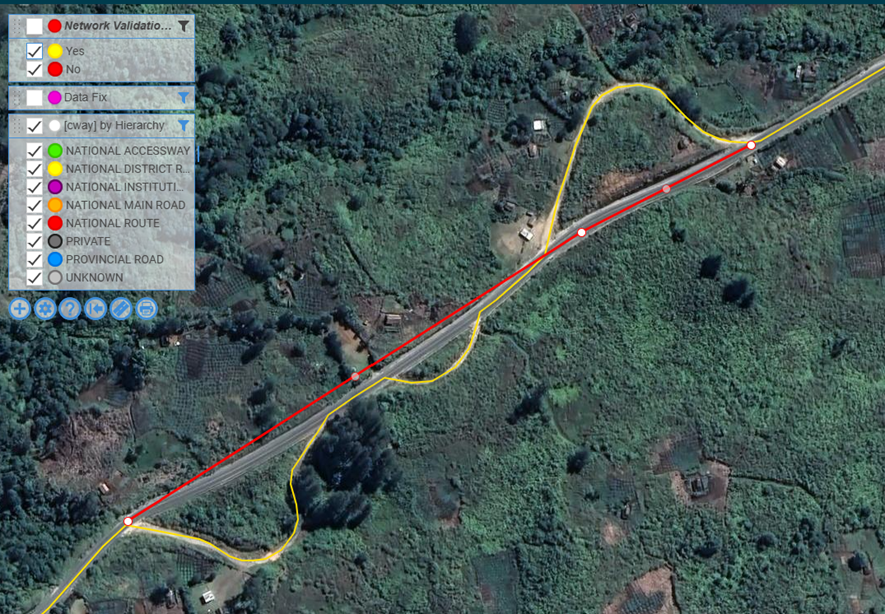
Progress of this task will be tracked using the “Network Validation Tracker” table – as part of the process of checking each road in a province, the associated record in the tracker table should be updated.
Note that short sections such as ramps or roundabouts have not had records created in the tracker table, and that the tracker records may look a bit odd around these locations as they draw a straight line across the roundabout – this is not something to worry about but is a consequence of the roundabout being its own “road” – the carriageway/centreline network is accurate in any case (centrelines in red, tracker record in yellow):


